Hey Guys,
My sister-in-law and nephew are coming in town in couple of weeks and I'm working on planning a road trip. I'd like to make a 4 day / 3 night trip with 2 nights camping and 1 night in a hotel. Camping three nights in a row is too much for the girls so I'd like to do the hotel on the second night between the camping.
We're planning to head to the Arizona / Utah boarder. The idea for the trip started with Antelope Canyon and since we want to make it a 4 day trip I'm working on adding additional destinations. Thanks to NVSteve's post it looks like Monument Valley and Bryce Canyon are good places to consider. Monument Valley looks closer to Antelope Canyon so I'm thinking those would be two good places. Steve also had pictures of the Wave, but I haven't planned enough ahead for that. It looks like there could be some other good hikes in that area in the Paria Canyon.
I'm trying to plan the itinerary and am looking for input that anyone has such as places they have camped, lodged, or eaten. Hiking or driving trails you've enjoyed. Any input is appreciated and I'll post pics after the trip for everyone to see.
Road trip to Arizona / Utah Boarder
Moderator: volvite

Have you thought about visiting Gooseneck as well if you're already in that area/direction?
http://www.panoramio.com/photo/9260274
http://www.panoramio.com/photo/9260274
Re: Road trip to Arizona / Utah Boarder
There are some great hikes in the area. Doubtful that you'll be able to score any permits for Coyote Buttes North (the Wave), but you should be able to get some for Coyote Buttes South, which is equally as scenic. You could also spend half a day or so hiking into Buckskin Gulch & back for a very awesome slot canyon experience, and it is right there in the Coyote Buttes area. Here's the link for the permits:AZ_Path wrote: We're planning to head to the Arizona / Utah boarder. The idea for the trip started with Antelope Canyon and since we want to make it a 4 day trip I'm working on adding additional destinations. Thanks to NVSteve's post it looks like Monument Valley and Bryce Canyon are good places to consider. Monument Valley looks closer to Antelope Canyon so I'm thinking those would be two good places. Steve also had pictures of the Wave, but I haven't planned enough ahead for that. It looks like there could be some other good hikes in that area in the Paria Canyon.
https://www.blm.gov/az/paria/obtainperm ... usearea=CB
If you do decide to go to Bryce, stop by the Paria BLM station and ask them if Cottonwood Canyon road is open. If it is, then it is a very short & straight shot to Bryce from there. Otherwise, you'll have to take the long way through Kanab. Plus, it'll take you right by Kodachrome Basin, which is a tiny & cool state park. With the amount of time you've given, Paige to Bryce (via Coyote Buttes) would definitely fill up your 4 days. If you need any help finding specific info, let me know.
No I hadn't. Thanks for the suggestion. Have you been there yourself? If so, did you hike or camp in the area?fat_frog wrote:Have you thought about visiting Gooseneck as well if you're already in that area/direction?
http://www.panoramio.com/photo/9260274
Thanks Steve. I figured you would have some input to share since you've explored the area quite a bit. I've enjoyed the pictures you posted and used it for planning this trip so thanks for sharing. How do the slot canyons at Buckskin Guluch compare to Antelope Canyon? Due to the popularity of Antelope, the required guided tour is more expensive than exploring some place on your own. It's $20 / person I believe plus your vehicle entry fee. If the slot canyons at Buckskin are equally beautiful, then we may try to save a little cost by going there instead of Antelope. The site for permits you posted seems to be down right now. Do you recall the permit cost?NVSteve wrote: There are some great hikes in the area. Doubtful that you'll be able to score any permits for Coyote Buttes North (the Wave), but you should be able to get some for Coyote Buttes South, which is equally as scenic. You could also spend half a day or so hiking into Buckskin Gulch & back for a very awesome slot canyon experience, and it is right there in the Coyote Buttes area. Here's the link for the permits:
https://www.blm.gov/az/paria/obtainperm ... usearea=CB
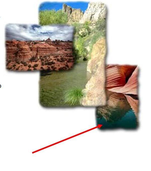
I browsed around on other areas of the site you linked. On this page (http://www.blm.gov/az/st/en/arolrsmain.html) there is a picture like what I pasted below. Do you know where the bottom right photo is taken? It looks like it could be around Lake Powell, but I just don't know the area that well. I see pictures similar to this one as I browse sites, but can't figure out where they are taken. It looks like a beautiful place.
Yes, I have. Gooseneck was a quick stop. It has a short walk/hike from a parking area. It's kind of like Grand Canyon...you drive to get there, and all of a sudden it opens up in front of you. Only difference is...area you can move about is not like Grand Canyon. Maybe you enjoy the view for up to 30 min. on that spot, and turn back to the parking area.AZ_Path wrote:No I hadn't. Thanks for the suggestion. Have you been there yourself? If so, did you hike or camp in the area?fat_frog wrote:Have you thought about visiting Gooseneck as well if you're already in that area/direction?
http://www.panoramio.com/photo/9260274
Oh, by the way, having a pair of binoculars might be a good idea. From where you stand to the bottom/water/river is quite far. If you happen to spot something on the bottom, you can only see it as a dot (or a pixel) w/o binoculars.
Antelope Canyon is pretty, and the rock is a bit redder than in Buckskin. The biggest selling point for Antelope & the guided tours is that you can take one at a certain time of day when the sun is overhead just in the right spot & it will send a shaft of light down to the bottom of the canyon. Extremely picturesque & probably 95% of the photos on the web are of the same thing. Buckskin probably has the same effect, although I've never seen anything posted as to times. Not really sure if anyone has even tried to figure out if you can get the same "look" as in Antelope. Buckskin is absolutely worth it, and you can avoid all the tourists and tours, go at your own pace, etc. It's still rated as the top slot canyon hike in the US, according to a number of different books. Words alone can't describe it. It's one of those places that one has to visit to fully understand how cool it is. Not sure how big of a hiker you are, but about 5 or 7 miles into Buckskin is a boulder jam that required rope the last time I was there. Being a slot canyon, the topography changes all the time, so you may not need rope now. Anyway, if you make it to that point, it would be a good time to turn around and make the return anyway, which would make for a good day hike.AZ_Path wrote: Thanks Steve. I figured you would have some input to share since you've explored the area quite a bit. I've enjoyed the pictures you posted and used it for planning this trip so thanks for sharing. How do the slot canyons at Buckskin Guluch compare to Antelope Canyon? Due to the popularity of Antelope, the required guided tour is more expensive than exploring some place on your own. It's $20 / person I believe plus your vehicle entry fee. If the slot canyons at Buckskin are equally beautiful, then we may try to save a little cost by going there instead of Antelope.
If you just want to hike Buckskin, you can just pay at the trailhead parking area. If you want permits for either Coyote Buttes North or South, you'll need to buy those from the Paria BLM field office, preferably by mail in advance. It cost us $5 for permits last year, but I wouldn't be surprised if they upped the price for this year. The coolness & beauty factor is definitely there, and I would be willing to pay a lot more than just $5 for a permit.The site for permits you posted seems to be down right now. Do you recall the permit cost?
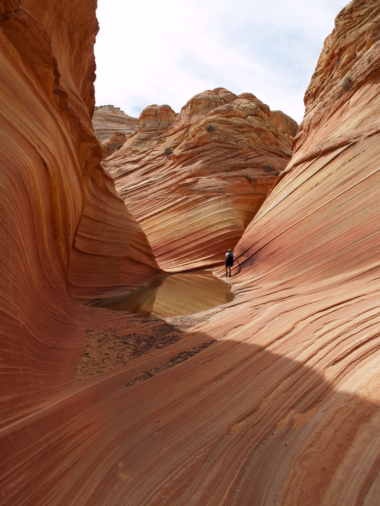
That is The Wave. Just compare the right side of the photo where the hiker is (see photo below this) to the photo you posted. Their photo was taken a few feet to the left of mine, but it is definitely The Wave. That's the difference between Coyote Buttes North and South. The North has scenery like that pretty much only when you get to The Wave. The South has scenery like that all over the place, although the road to the parking area requires 4x4. I'd be happy if someday that make the whole Vermillion Cliffs area into a National Park or Monument, minus the development.I browsed around on other areas of the site you linked. On this page (http://www.blm.gov/az/st/en/arolrsmain.html) there is a picture like what I pasted below. Do you know where the bottom right photo is taken? It looks like it could be around Lake Powell, but I just don't know the area that well. I see pictures similar to this one as I browse sites, but can't figure out where they are taken. It looks like a beautiful place.
I think I would like to do both Buckskin Gluch and Coyote Buttes South. It seems like each of them would make for a good days activity. How long would you estimate the drive from Coyote Buttes South to Buckskin Gluch to be?NVSteve wrote: If you just want to hike Buckskin, you can just pay at the trailhead parking area. If you want permits for either Coyote Buttes North or South, you'll need to buy those from the Paria BLM field office, preferably by mail in advance. It cost us $5 for permits last year, but I wouldn't be surprised if they upped the price for this year. The coolness & beauty factor is definitely there, and I would be willing to pay a lot more than just $5 for a permit.
So is the South not accessable without 4x4 or are you just looking at a longer drive to get there?The South has scenery like that all over the place, although the road to the parking area requires 4x4.
If we plan to go to Coyote Buttes South one day and Buckskin Gluch another, what do you think would be best for the third day. I was thinking either Bryce or Monuement Valley. It looks like either of those is going to require some driving. What do you think. Any places you'd recommend instead? I really appreciate all the help.
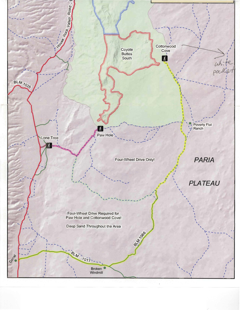
It's about 32 miles from the Wire Pass Trailhead (Buckskin Gulch) to the Cottonwood Cove Trailhead (Coyote Buttes South). You can also access Coyote Buttes South via the Paw Hole Trailhead, which is about 1/2 the distance, but would require more hiking to get to the area around Cottonwood Cove. Here's a mileage chart:AZ_Path wrote: I think I would like to do both Buckskin Gluch and Coyote Buttes South. It seems like each of them would make for a good days activity. How long would you estimate the drive from Coyote Buttes South to Buckskin Gluch to be?

And an overview map:
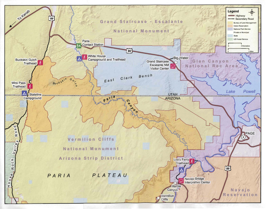
If you camp, the Stateline Campground is your best bet (no water, so bring lots of your own). There is another "campground" just south of the Paria BLM office, but it's usually packed with backpackers either heading out or returning from Buckskin Gulch.
A Coyote Buttes South map:
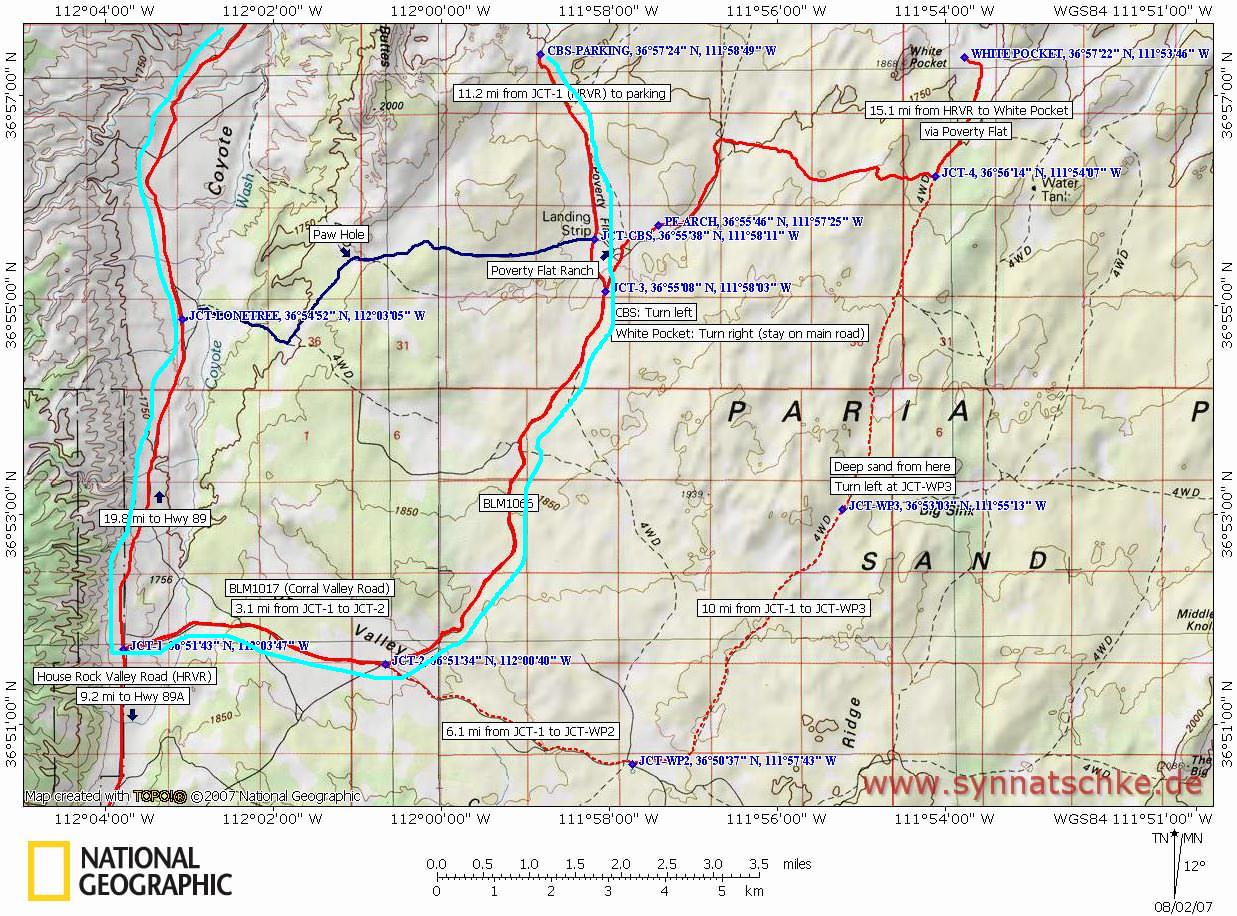
And another. I highlighted the route to the Cottonwood Cove Trailhead in light blue. When you're in the area, you'd think it would be super easy to find your way. I had my GPS with me & a couple of paper maps & still ended up taking one wrong road. I didn't try going by the BLM mileage chart, so that may be more accurate/the most accurate way to get around.
Some general info:
You'd definitely need a 4x4 to get to either trailheads in the south.So is the South not accessable without 4x4 or are you just looking at a longer drive to get there?
Well, Bryce could possibly be a lot closer to deal with than Monument Valley. Bryce is about 130-140 miles from the Wirepass Trailhead (Monument Valley is ~165 miles), via the highway & Kanab. As I mentioned before, stop in the BLM office and ask if Cottonwood Canyon Road is open, because that will cut many miles off the distance to Bryce. If you do Coyote Buttes South the first day, then Buckskin the next, you'll still have more than enough time to drive from Buckskin up to Bryce. At least around Bryce they have lodging, in addition to the NPS campgrounds. Or, you could even stay in a motel in Kanab, then drive to Bryce the next day. If you do make it to Bryce the same day as Buckskin, that would give you a fair amount of time to spend at Bryce. Monument Valley is one of my favorite places, but I've never gone there without spending at least 1 night. It isn't a good place to do the typical European whirlwind-type tour, but it can certainly be done if need be. Bryce adds a bit of a break to the shadowless desert & adds cool air and trees.If we plan to go to Coyote Buttes South one day and Buckskin Gluch another, what do you think would be best for the third day. I was thinking either Bryce or Monuement Valley. It looks like either of those is going to require some driving. What do you think. Any places you'd recommend instead? I really appreciate all the help.
My wife called the Coyote Buttes Permit office since the link was not working and they said that the North and South both give access to The Wave and both are booked far in advance. I'm also 4x2 so that would mean that the South wouldn't have been an option for me anyway so I guess Coyote Buttes is not going to be part of this trip.
My wife also asked about Buckskin Gulch since she noticed the site says there is wading through cold water for portions of the hike. The person she spoke with said there are areas to hike where you won't have to wade through water. I'll have to call back for specific information since she didn't ask those questions. I think we need to avoid the strenunos parts such as wading through water. I'm taking my 38 y/o sister-in-law, 9 y/o nephew along with my wife and 5 month old daughter.We're up for hiking distances of several miles a day, but I can't take too strenuous of a route given my group.
So I plan to spend one day at Buckskin assuming we will be able to hike a few miles in without needing ropes or going into cold water. That leaves two days elsewhere. I'm still thinking either Bryce or Monument Valley. Which do you think has more to offer to fill our days? You mentioned Monument Valley being one of your favorite places, and staying for at least a night. What do you when you are there?
Thanks again for all the input. It's been so helpful for planning this trip. I hope it comes together nicely.
It sounds like your wife may have spoken to a doorknob. Both areas give access to The Wave, but one absolutely must have a permit for Coyote Buttes North. And trust me, accessing The Wave from the south is NOT for the timid-I'm very surprised they even mentioned it. Did the person on the other end of the phone mention the daily lottery? They have 10 tickets available from the Paria BLM station daily, for both the North and South. If fewer than 10 people show up, everyone can get one. If more than 10 people, then they have a lottery. These lotteries are done the day before the pass is valid, meaning that you could stop by & do the lottery (maybe even get lucky), head to Buckskin for the day, and then returning the next day for The Wave (assuming you win). If it were me, I'd try it. Even getting tickets for The Wave online is extremely hard because it is also done by lottery. But, it's also worth the effort because it really is a very unique landform.AZ_Path wrote:My wife called the Coyote Buttes Permit office since the link was not working and they said that the North and South both give access to The Wave and both are booked far in advance.
Yeah, there's no way I'd even think about driving that road in a 4x2.I'm also 4x2 so that would mean that the South wouldn't have been an option for me anyway so I guess Coyote Buttes is not going to be part of this trip.
It all depends on previous weather conditions. When I backpacked the whole thing, there were maybe 3 spots where I had to wade through water & it was an inch or so below the bottom of my shorts at the deepest. I apologize for not mentioning that before-I guess I just take it for granted. I have heard from others who have gone after heavy rains & they literally had to float through a number of sections. When I was there last year, we hit it just a few days after some heavy storms & there was lots of water and tons of mud. Either keep an eye on the weather, or contact the BLM office a day or two before your trip to see if they have the current conditions.[/quote]My wife also asked about Buckskin Gulch since she noticed the site says there is wading through cold water for portions of the hike. The person she spoke with said there are areas to hike where you won't have to wade through water. I'll have to call back for specific information since she didn't ask those questions. I think we need to avoid the strenunos parts such as wading through water. I'm taking my 38 y/o sister-in-law, 9 y/o nephew along with my wife and 5 month old daughter.We're up for hiking distances of several miles a day, but I can't take too strenuous of a route given my group.
Let me start with Monument Valley. One of the only things you can do there is to take the dirt road loop, which is actually fairly short. It takes you in much closer to a lot of the interesting formations, but in order to really see the area, you'd have to take a tour or hire out a guide. I have no idea on costs since I've never taken any of their tours. But, there is some really fantastic looking scenery involved that you otherwise wouldn't see on your own, at least according to all the photos I've seen posted. I always stay at their campground because sunsets and sunrises are so spectacular, and I always do a bit of hiking from there (even though you really shouldn't).That leaves two days elsewhere. I'm still thinking either Bryce or Monument Valley. Which do you think has more to offer to fill our days? You mentioned Monument Valley being one of your favorite places, and staying for at least a night. What do you when you are there?
Bryce is far more of a productive stop. There are a ton of hikes you can take, from short to long, and it takes literally minutes to be in the midst of the hoodoos from the majority of the parking areas. If you get bored of the hikes, you can drive down to the end of the road & back, stopping at all the scenic pullouts (or just take the park shuttle & do the same). Maybe 15 miles to the west of Bryce is another scenic area you drive through called Red Canyon. Or, as I mentioned previously, about 20 miles to the east of Bryce is Kodachrome Basin, which also offers hiking & nice campgrounds.
Glad to help.Thanks again for all the input. It's been so helpful for planning this trip. I hope it comes together nicely.
Last edited by NVSteve on Wed Apr 01, 2009 1:49 pm, edited 1 time in total.
I originally asked my wife to call about getting permits for the south since we thought it didn't have a long waiting list like the north does and since I couldn't get the link you posted for permits to work. They told her that the waiting list for the south is several months long and the only option we would have is the lottery.NVSteve wrote: It sounds like your wife may have spoken to a doorknob......
My wife called again today to ask about how far we could get into Buckskin before we would encounter water. The person she spoke to said we may want to consider the White House trailhead because we could hike from the campground to buckskin along the edge of the river and we wouldn't have to wade through. I'm not sure we'll be able to see much of buckskin once we get to it though. I was hoping to be able to go a little ways into the canyon and then turn around once we encountered deep water. How far would you guess we could hike in from Wirepass until we hit water? If we could get at least a mile then it would be worth it.
It all depends on previous weather conditions..... When I was there last year, we hit it just a few days after some heavy storms & there was lots of water and tons of mud. Either keep an eye on the weather, or contact the BLM office a day or two before your trip to see if they have the current conditions.
I'm thinking Bryce is proabably where we will go then. If Cottonwood Canyon road is open, will I need 4x4?Bryce is far more of a productive stop....
AZ_Path wrote:They told her that the waiting list for the south is several months long and the only option we would have is the lottery.
I'm not sure how many of the poor Europeans who stand in line for the lottery end up choosing instead to go to Coyote Buttes South. I'm guessing less than 2%. All the times I've been there, all the tourists are driving around in rented cars, not 4x4's or a SUV. I'd say you have a great chance to "win" permits for the south, but permits for the north would probably be virtually impossible for you to win for your whole group.
I've been there in April, May & September. I've never seen any water in the Paria between White House and the confluence with Buckskin. The Paria is only a river every once in a while, like whenever it rains & whenever the snows start to melt. Anyway, the hike from White House to the confluence with Buckskin sucks. The canyon is very wide and the sand very soft. Not scenic at all until you get to Buckskin, which is a few miles of grunting through the sand. I would say "hell no" to that suggestion.My wife called again today to ask about how far we could get into Buckskin before we would encounter water. The person she spoke to said we may want to consider the White House trailhead because we could hike from the campground to buckskin along the edge of the river and we wouldn't have to wade through.
I think it's about a mile until you get to the first part of Buckskin. It's a relatively wide canyon that just narrows all of a sudden into a big narrow crack. That first segment is actually quite dramatic and will give you a great feel for the canyon. Once you make it through that little segment, it opens up again before getting narrow again for the next 10 or so miles. I'd imagine, if memory serves, that you should be able to hike at least a couple miles from the trailhead before you hit anything with water. If it has been dry, you could probably extend beyond that 2 miles. It's really kind of impossible to know or predict. You may encounter a few little dropoffs, depending on how the rocks are wedged in there right now, but nothing you need rope for. I'd say go for it, especially since you'll be in the area anyway. It isn't that far from the highway, so it would be worth it to check it out.I'm not sure we'll be able to see much of buckskin once we get to it though. I was hoping to be able to go a little ways into the canyon and then turn around once we encountered deep water. How far would you guess we could hike in from Wirepass until we hit water? If we could get at least a mile then it would be worth it.
When Cottonwood is open, it is generally open for all types of vehicles. You would just have to check on the road conditions at the BLM office. The biggest problems I've seen with that road are washouts and debris scattered over the road. But, unless half the road is literally gone, a 4x2 would have no problem with it if it is officially open.I'm thinking Bryce is proabably where we will go then. If Cottonwood Canyon road is open, will I need 4x4?

Find Your Forum!